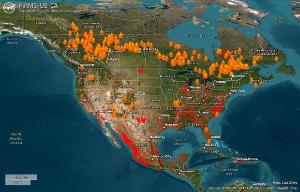
Canada is experiencing its most destructive wildfire season on record, as hundreds of blazes burning from coast to coast continue to send tremendous plumes of smoke into the atmosphere. Thick bands of soot and smoke particles captured over the last month by satellite images showed the extent of the air pollution traveling south over the Canadian border and into the United States, producing hazy skies and triggering air quality alerts across parts of the country.
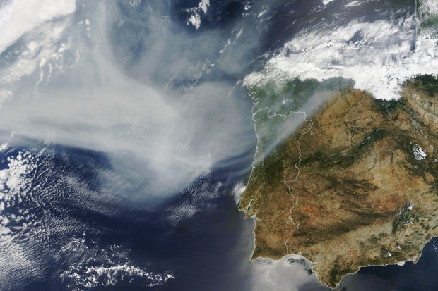
In late June, the smoke plume stretched as far as Europe, while air quality alerts were effected again for millions of Americans.
Wildfire season typically happens around this time of year in Canada, which is home to about 9% of the world’s forests. But with the season occurring annually from May until October, devastation seen from the outset this year put the country almost immediately on track for its worst season in more than 30 years. Out-of-control blazes have cropped up in nearly every corner of Canada and forced thousands of people to evacuate.
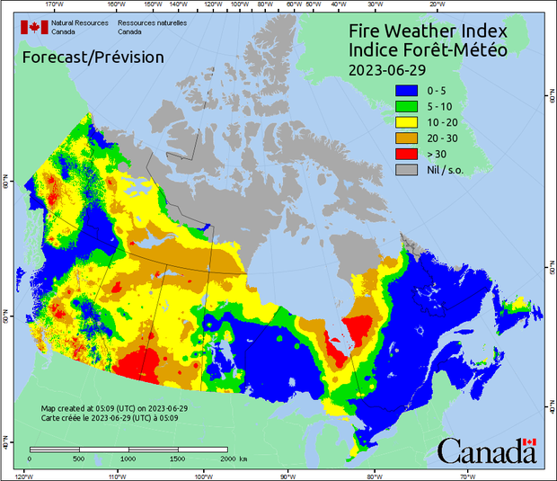
A map updated daily by the Canadian Interagency Forest Fire Centre shows how widespread the wildfires have become. Eastern provinces like Quebec, Ontario and Nova Scotia have been hit particularly hard this year by large and at times uncontrollable blazes.
Officials on Wednesday reported the highest number of current active fires in Quebec, with 112, down from 113 on Wednesday and 117 on Tuesday. British Columbia, along Canada’s west coast, had the second-highest number of active blazes — 94, which was down from 99 two days earlier — followed by Alberta and Ontario.
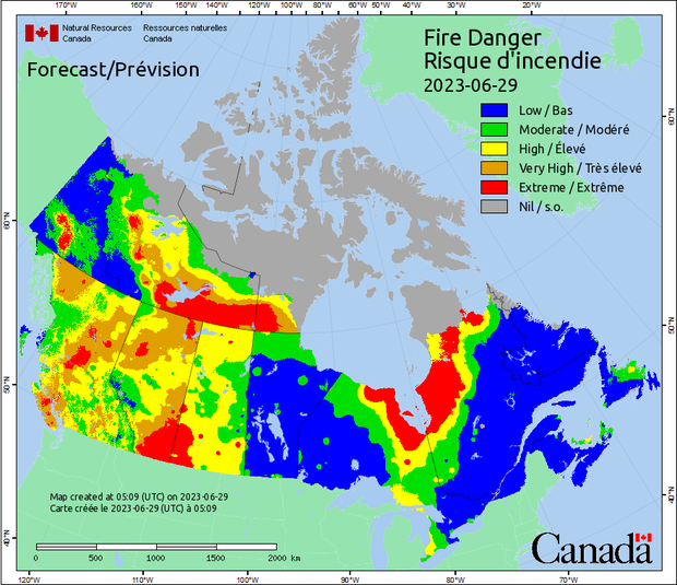
The broad extent of the fires — from the westernmost provinces to the eastern ones — is unusual, particularly so early in the year, Canadian government officials have said. Political leaders, including President Biden, and environmental experts have pointed to the causal link between rising temperatures driven by climate change, as well as drought, and the extreme wildfire season that Canada is experiencing now. Plus, as CBS News previously reported, harsh weather conditions in Canada are fueling the fires and making it harder for firefighters to combat the flames.
As of its most recent update, the interagency fire center has recorded 3,031 wildfires since the beginning of 2023. The fires have scorched at least 8.1 million hectares — or around 20 million acres — of land across Canada this year. That number, reported on Thursday, had jumped 300,000 hectares, or nearly 750,000 acres, over just 48 hours. The acreage burned so far this year recently surpassed the amount of land burned in 1989, which previously held Canada’s annual record, the country’s National Forestry Database reported.
There were 500 active fires burning in Canada on Thursday, according to the latest interagency tally, with five new blazes recorded since officials put out the previous day’s update. The agency’s overall tally rose from 483 active fires reported on Wednesday, following a slight dip from the 490 active blazes reported the day before.
After wildfire smoke traveling south from eastern Canadian provinces brought a marked spell of haze, fumes and copper skies to the northeastern U.S. earlier in June, states being affected most severely this week are in the Midwest, and, again, in the Northeast, with air quality in Washington, D.C., Chicago and Detroit ranked as the world’s worst, second-worst and third-worst on Thursday, according to the Swiss air quality technology company IQAir.
Air quality in Chicago and Minneapolis ranked as the world’s worst and second-worst earlier in the week, with Detroit appearing near the top of IQAir’s global rankings on Wednesday and Toronto taking the sixth spot. By Thursday, the company ranked air quality in Minneapolis and New York City in seventh and eighth place, respectively, and the air quality in Montreal was not far behind.
Meanwhile, NASA published an image Tuesday that showed a thick band of smoke from the wildfires in eastern Canada drifting across the Atlantic Ocean and reaching as far as Europe.
As of Thursday, a slight majority of Canada’s active fires were still classified as “out of control,” with 256 blazes in that category. Of the remaining wildfires being monitored, 159 were considered “under control” and another 85 were “being held,” which is the label assigned when a fire is not under control but also is not moving.
Canadian officials have declared a “national preparedness level 5” in response to the wildfires, which means the country will deploy any resources necessary to combat the flames. Mr. Biden said earlier this month that firefighters from the U.S. would be sent to Canada to assist in the effort, alongside others from Australia, New Zealand and South Africa, a research officer from the Canadian Forest Office previously told CBS News.